|

Caretakers of the past, stewards of the future.

THE LEGACY: LIVING with the EFFECTS
Keweenaw’s Mining Heritage
The legacy of industrial mining - from mill to town to stamp sands to ecological consequences - appears throughout the landscape in and around Gay. Visitors observe the tall smoke stack, the concrete and sandstone mill remains, the rows of company houses, and the extensive shoreline deposits of dark stamp sands that now extend down to the Traverse River Harbor. These scattered remnants are a key example of the “boom and bust” mining heritage at this site. The two Gay mills, some of the most profitable at the time, discharged millions of tons of stamp sand tailings into an enormous pile out from the shoreline into Big Traverse Bay.
This site is representative of many on the Keweenaw, reflecting both rich cultural histories and consequential sites of waste, toxicity, and harm that need to be remediated. Although the mills operated for only about thirty years and built a social and work life for many residents, they left over a 100-year legacy of migrating stamp sands threatening the fishing heritage and beautiful beaches valued in the Keweenaw. Of the three large stamp sand sites in Lake Superior at Freda-Redridge on the western side of the Peninsula, and Sand Point near the foot of Keweenaw Bay, Gay creates the most concern.

Top view Mohawk sand belt conveyor support from atop the 30-foot cliff of Gay sand pile at water’s edge. Remnants of the delivery system of stamp sands from the Gay mills to Big Traverse Bay. Credit: Cooper Sheldon. November 2017

2017 Drawing of the Gay stamp sand conveyor system by John Arnold for Keweenaw National Historical Park. The remains of the Mohawk concrete launder and sand conveyor are still visible today. The Wolverine launder to the south is no longer present.
Saving Buffalo Reef
Gay’s stamp sands became a concern for commercial fishing and residents in the Big Traverse Bay by the early 2000s. The Great Lakes Indian Fish and Wildlife Commission (GLIFWC) recorded a decline in whitefish and lake trout in Big Traverse Bay, which supplies a significant portion of the commercial catch of fish along the south shore of Lake Superior. The arrival of the stamp sands at the mouth of the Traverse River prompted a regular dredging by Michigan and the Army Corps of Engineers to protect the juvenile whitefish habitat south of the harbor. Michigan Tech scientists began to study the movement of stamp sands into the Big Traverse Bay and overtopping Buffalo Reef.
For two decades, entrepreneurs, research scientists, and state, tribal, and federal governments have studied the possibility of containing, commercializing, or removing the Gay stamp sand pile. The U.S. and Canada now consider migrating stamp sands one of their highest priorities. The U.S. EPA, U.S. Army Corps of Engineers, GLIFWC, and Tribes all urge immediate action to protect Buffalo Reef.
In 2017, “Saving Buffalo Reef,” the Buffalo Reef Protection and Restoration Project, began as a collaboration of state, tribal, and federal organizations. The Great Lakes National Program Office (GLNPO) and the Michigan Department of Environment, Great Lakes, and Energy (EGLE) gave about seven million dollars, slated largely for dredging and planning activities. Dredging began at the Traverse River Harbor and at the “trough” off of Buffalo Reef, and extended for four years.
In 2008-2012, scientific studies began to confirm that the stamp sands in the Bay threatened the health of Buffalo Reef. For years the black sands had accumulated in a trough (ancient river bed) north of the reef, but had filled to the extent that stamp sands began moving into cobble fields of the reef. Models suggested that within a matter of a few short years (10 years) 60% of the reef would be covered with mine tailings. Short- and long-term solutions became imperative. The EPA funded a feasibility study for a long-term solution. The Keweenaw Bay Indian Community, State of Michigan, and US Army Corps of Engineers formed the “Buffalo Reef Task Force” to consider alternatives.
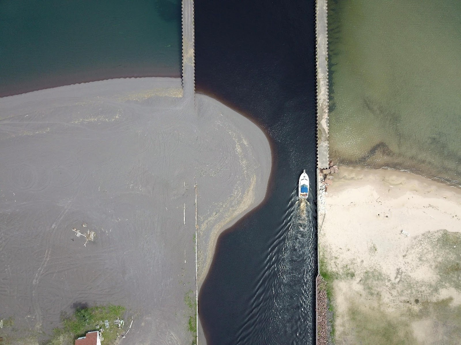
An aerial view of the entry of Traverse River into Lake Superior. The regular movement of stamp sands over the top of the breakwater requires annual or biennial dredging to keep the small Traverse River Harbor, home of a commercial fishing fleet, open to entry. Notice the black (stamp) sands on the left to the north of the channel compared to the white (natural) sands to the right. The regular dredging keeps the natural sands intact, at an expense of approximately $500,000 per year. Credit: W.C. Kerfoot, Michigan Tech University, GLRC

The Buffalo Reef Task force receives input from multiple stakeholders that include local townships, the Keweenaw Bay Indian Community (KBIC), Michigan natural resource and environmental agencies, the Environmental Protection Agency, the National Park Service, and the US Army Corps of Engineers (USACE). Credit: Buffalo Reef Task Force. Michigan EGLE.

Dredging of the sands from the entry to Traverse River Harbor and the “trough” adjacent to Buffalo reef during the summer and fall will be an intermediate solution (3-5 years) while implementation of a more permanent solution is discussed and funded. Credit: W.C. Kerfoot, Michigan Tech University, GLRC.

Aerial view of large bermed-ponds on the Gay stamp sands to contain sands dredged 2019-2020. Removal of 36,000 cubic yards from Traverse River Harbor “overtopping” and 178,000 from the “Trough.” This interim strategy will continue until a permanent solution for containing the stamp sands is implemented or project funding is terminated. View from south looking north with the Mohawk Mill smokestack in the distance. Credit: W. C. Kerfoot, Michigan Tech University, GLR
A Lake Superior Story
The Keweenaw Peninsula provides unique stories, but not unique problems. Both historic and contemporary mining sites force us to ask: Where do we put hazardous mining waste? Canada banned discharge into the Great Lakes, and the U.S. 1972 Clean Water Act prohibits the practice, but it continues in other parts of the world. Tailings released prior to environmental regulations are considered “legacy” mining sites and some U.S. state programs are devoted exclusively to cleaning up abandoned mines.
The “Saving Buffalo Reef” project and the Torch Lake Superfund site are examples of the technological challenge and expense in containing the harmful effects of “legacy” tailings. These days there is more concern about potential environmental effects. More and more, mine companies are encouraged to minimize their “footprint.” The perpetual character of mine waste is a challenge for water quality, the environment, and human health. Fortunately, the Keweenaw mine wastes did not involve high concentrations of sulfur, which would have led to acid mine drainage, an issue at many other locations.
Gay’s industrial heritage of native copper milling and the lessons learned from stamp sand production and its environmental effect resonate through all historic mining communities in the Great Lakes. It is truly a Lake Superior story.

Adkameg (Lake Trout). In this drawing, the Adkameg, a member of the Fish Nation, has a spiral line leading from the heart to the mouth illustrating the importance of its relationship with all other species. Respect and reciprocity from the heart are integral to all species nations, including humans. Credit: Matt Dellinger. 2020.

Lake Superior from Gay Sands. Credit: Cooper Sheldon. October 2017

 Keweenaw County Historical Society